Purulia, as we know it today, was officially born on 1st November, 1956. In ancient India, the Vajra-bhumi region had 16 Mahajanapadas and "Puruliya" was one of them. Little is known about it after that until the presence of the East-India Company in the country, which formed the Jungle Mahals districts in 1805, comprising of 23 mahals and parganans, including Purulia. Subsequently in 1833 Jungle Mahals was broken down to form the Manbhum district, which included section of Burdwan and Bankura, and also parts that are currently in Orissa and Jharkhand. The headquarters was at Manbazar, which was transferred to Purulia in 1938.
Purulia district is a part of Chotanagpur plateau is located at the westernmost edge of the state of West Bengal. It is a distinct region of transition between the Damodar plains of West Bengal and the ancient plateau of South-East Bihar. The Hooghly estuary and the Bay of Bengal are around 200 km from the centre of Purulia. The map coordinates are - 23° 42' 00' North and 22° 42' 35" South latitude and 86° 54' 37" East and 85° 49' 25" West longitude. It is intersected by the Tropic of Cancer. Purulia, which is a part of the peneplains of Ranchi, has been classified as an economic region by the Govt. of India owing to its major physiographic characteristics.
The shield-rim land layout of Purulia displays two types of texture relief This distinction of texture relates to diverse cycles of erosion and also to dissimilarities in lithology. The highlands rise steeply from 300 metres but the slope becomes average above 500 meters, looking more like an uplifted plain surface. Absolute relief intensifies towards the west and the south marked by a line of sharp inclines but almost flat-topped arches shrouded in lush vegetation. The rest of the district has a gently undulating landscape with sporadic Hillocks of hard rocks (Panchet Hill). These are residual Hills, that bear witness to the high plateau of primeval times which got eroded down over time to the present land-form.

The highlands of Purulia are actually the vestiges of the offshoots protruding from the Ranchi plateau to the west and operational as watersheds of the Subarnarekha-Kasai- Damodar group of rivers. At the extreme north-west is the trijunction of Purulia, Ranchi and Hazaribagh districts where the east-flowing Subarnarekha bends southwards to designate the western boundary of the district and divide a spur which once stretched from Ranchi - Muri to Jhalda - Balarampur like an enormous tongue. The eastern part of this abbreviated tongue, known as Ajodhya Pahar (Ayodhya Hills), forms the main highland region of Purulia district. It acts as the watershed between the rivers Kasai and the Subarnarekha.
To the west and south of Ajodhya Pahar (Ayodhya Hills) occurs a number of residual Hills, isolated and detached from the parent body. In Jhalda many such outliers rising steeply from a relatively smooth surface at 300 meters to above 500 meters diversify the landscape on either side of the Jhalda-Muri road. Their ridge lines have an east west trend and an average altitude of 500 meters. The 688 meters high Chamtu is the highest point on the south - western flank. Some of these prominences are wooded (such as the Kalimata Palas forest on either side of the Baghmundi - Jargo road) and others are devoid of vegetation.
The words 'buru' means 'pahar' (Hill) In Santhal language. Such as, Gargaburu, Chemtuburu, Gagaburu, Mathaburu, etc. There is an abundance of huge boulders, coarse rocks, gravels, and large sand particles on the river beds of this region, which are called 'rahr' in local lingo. Therefore, Purulia is also identified as the 'rahr' district of West Bengal.
Ajodhya Hills is about 320 Sq Km, which includes sections of Baghmundi, Jhalda, Balarampur and Arsha Blocks in Purulia district. The origin of the word 'Ayodhya' or 'Ajodhya' is 'Ajhaida', a Dravidian word. Ajhai = large and Da = daha / abyss. The slightly L-shaped Ajodhya Hills is approximately 2200 feet in height and covers 10 miles in width and 32 miles in length. The tribal communities of Purulia consider it sacred. There are 70 hamlets In Ajodhya Hill, 2 Gram Panchayats - Ranga and Ajodhya, a library, Ajodhya Hill hospital, an office of Comprehensive Area Development Corporation, water project, and more.
Legend has it that, Ram, Lakshman, and Sita visited Ajodhya Hills during their exile. Ram created a fountain by penetrating the ground with his arrow for a thirsty Sita who drank the water. During Disum Sendra, the Hunting Festival, tribals from Ajodhya Hills and surrounding areas visit this place - they drink water from the legendary fountain Sita Kund, and subsequently embark on their hunting expeditions.
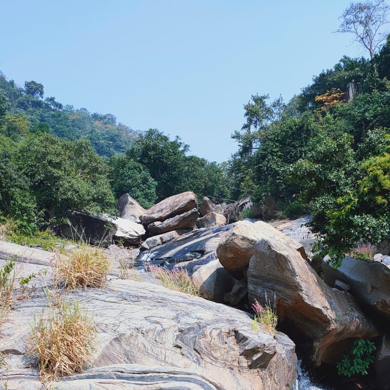
Ajodhya Hills is a preferred destination for travellers from Kolkata who are nature enthusiasts, especially beautiful hills and forests and waterfalls. This stunning location is surrounded by all three. Sal, shimul, pine, shegun, and shirish are the main trees that make up the green forest cover, and the seasonal colour changes add to the beauty of the area.
Ajodhya Hills is a part of the Dolma Hill Range, which is located on the Bihar-Puruliya border. It is comprised of many peaks of various heights - the highest peak being Gorga-buru at 855 m. Numerous wild animals inhabit the mountain forests - such as, wild boars, elephants, wolves, deer, cheetahs - making wildlife watching is one of the chief draws of Ajodhya Hills. There are also various trekking and hiking options for the adventurous tourists.

Copyright © 2023 - Palash Blossom Estate
All Rights Reserved.